Not close to retirement
As Florida’s population grows, what were once sleepy, quaint municipalities have grown into robust cities with demanding infrastructure needs.
Such is the case for the city of Port St. Lucie, a municipality of more than 170,000 people located midway between Cape Kennedy and Ft. Lauderdale on the Atlantic coast. At one time a quaint retirement community, the city has nearly doubled its population since 2000, with much of the expansion occurring west of the city’s primary waterway, the North Fork of the St. Lucie River (NFSLR).
By 2002, city officials realized the area’s exponential growth would require a third bridge to relieve the burden on the area’s other two bridges, which were already congested by increasing travel demand. The concept of a third bridge had been part of the city’s master plan since the 1980s.
However, planning bridge construction in coastal Florida is challenging because of an abundance of sensitive wetlands. This was particularly true for the city of Port St. Lucie, as the area deemed the most suitable for a new bridge was 1,000 acres of wetland ceded to the Florida Department of Environmental Protection in 1995 and now known as the Savannas Preserve State Park, through which the NFSLR flows.
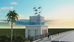
A tiled mosaic on the side of Crosstown Parkway.
Smooth move
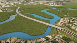
The proposed 4,000-ft-long bridge is part of the 2-mile Crosstown Parkway Extension Project, which when completed will connect the existing Crosstown Parkway from Manth Lane on the west side of the NFSLR to Rte. 1 on the east side of the waterway. Construction of the first 6 miles of the Crosstown Parkway began in 2003 and was completed in 2010. When the extension is finished, it will be a six-lane divided highway and will serve as a multimodal transportation alternative featuring accommodations for automobile, bicycle, pedestrians and public transit.
“We actually began the PDE for the extension and bridge in 2003,” said Frank Knott, project manager for the city of Port St. Lucie, the ninth-largest city in Florida. “At that time the two existing bridges already had bottlenecks. If there was a breakdown or accident on the bridges, traffic could be backed up for more than a mile.”
Knott said the city didn’t want to recreate that with a new corridor and bridge.
“It goes back to what happened on Port St. Lucie Blvd.,” he said. “That’s a six-lane road with three lanes both ways and the back of the sidewalk up against the right-of-way line. There are tons of driveways, and it’s a major commercial corridor in the city. It’s a nightmare from 6:30 a.m. to 8:30 a.m. and from 3:30 p.m. to 6:30 p.m. That’s where this vision came from—we didn’t want to replicate that. The Parkway is limited access with the only cross streets at signals and everything else a right in/right out.”
Despite the demand for a new bridge, Knott knew that getting a new one built across the wetlands would be challenging, adding, “We just wanted to get from Manth to U.S. 1.”
Despite two lawsuits, one filed against the Federal Highway Administration (FHWA) and the Florida Department of Transportation (FDOT) by the Conservation Alliance of St. Lucie County and the Indian Riverkeeper, and the second one filed by the Audubon Society against the South Florida Water Management District, the city expects favorable rulings and the permits to be issued by the end of the year.
“The issue in the first suit had to do with alignment,” said Knott. “The groups wanted us to place the bridge in a different location than the one selected. The second suit sought to deny the permit issued by the South Florida Water Management District, claiming the project would lead to the destruction of state preserve land on the NFSLR and thus destroy the area’s water quality.”
One of the advantages the city of Port St. Lucie had in the permitting process proved to be the 2013 construction of the Indian Street Bridge in Martin County, just south of the city of Port St. Lucie. That bridge was completed in 2014, and crossing the South Fork of the St. Lucie River faced similar environmental hurdles. Knott said that the FWHA and FDOT were well aware of the challenges presented by the Indian Street Bridge and were prepared for the permitting process.
“We knew what the issues were going to be and those agencies were very cooperative guiding us through the process,” Knott said.
Local revenues and bond money funded the first 6 miles of the Parkway, but now that the project crosses state lands, Knott said it has become eligible for federal money to help pay the $150 million price tag, much of it dedicated to securing right-of-way and the construction of the bridge.
“Of the 93 properties we needed for the 330-ft right-of-way, all but three have been secured,” he said, adding that the parkway had previously been a two-lane road with only 80 ft of right-of-way. “The additional right-of-way allowed for the six lanes, along with earthen berms, bike lanes, off-street parking and a pedestrian walkway. We wanted to create a park-like setting for this corridor.”
One of the selling points of the Crosstown Parkway is that it provides a smoother flow of traffic as it traverses a dense residential and business corridor. Rachel Back, P.E., project manager for RS&H, said the benefit of the parkway is that it is a limited-access roadway with only eight traffic lights between I-95 and Rte. 1, and no driveway access.
“The existing 6 miles of the corridor are already heavily used by residents, both cyclists and pedestrians alike, who enjoy the new thoroughfare,” said Back. “The bridge approaches will include architectural towers featuring tile mosaics of an image created by famed wildlife artist and conservationist Guy Harvey, commissioned by the city, as well as sculptures voted on by the residents.”
Back said the bridge clearance will be 18.6 ft vertically above NFSLR and Coral Reef Waterway, and 75.5 ft horizontally for these waterways. (Evans Creek is not classified as navigable, so it doesn’t require clearances.)
An overhead view of the six-lane divided highway.
Super idea
The most innovative part of the extension, Back said, is the creation of a “superstreet,” a non-traditional intersection, the first of its kind in Florida.
PD&E analysis revealed more turn lanes would be needed for the Parkway’s proposed intersection than what was in the initial concept.
“We were showing it would fail,” Back said, adding, “The level of service would be ‘E’ in the design year and ‘F’ 20 years later, all failures.” Intersections are typically designed to achieve a level of service of “D” or greater.
Back said that when RS&H and Archer-Western pursued the design-build project, the team looked for options to improve the project as well as cut costs.
“Based on the traffic volume we were seeing in our studies, we thought a superstreet would be a good alternative,” Back said. “It required two more signals but significantly less pavement, so it was a wash. We submitted it as an Alternative Technical Concept (ATC), and to the credit of city officials, they endorsed it.”
Back said the superstreet requires all traffic from the cross street (Floresta Blvd.) to turn right and proceed 1,500 ft to a signalized U-turn, while the through traffic proceeds as it would in a normal intersection. In order for a superstreet to work, the through traffic must be significantly greater than at the cross street. “The intersection presented a favorable ratio,” she said.
Knott said there was a significant amount of push-back from the public on the superstreet concept, but during the ensuing public meetings, members of civic groups, HOAs, commercial interests and school transportation officials slowly began recognizing its merits.
“We designed the plan very conservatively, so the design-build team could have some flexibility,” Knott said. “And that is what they did by coming up with the alternative technical concept,” he said, adding “The city continues the public education process right through the 2018 completion date, as research shows that, when used properly, the superstreet leads to a high level of safety and efficiency.”
Knott said while he looks forward to the completion of the superstreet and new bridge and what it means to the city of Port St. Lucie, he can’t help but think of Walter England, the city’s engineer in the 1990s who envisioned a linear parkway.
“It was a progressive idea for its time and much of the credit for the Parkway goes to him,” he said. “I just don’t know if he realized how popular it would become.”
Back added that “the city wanted this to be a very good project. They wanted a signature bridge, something extraordinary. Their ability to understand the advantages of the superstreet was part of that.”


