Will drones transform bridge inspection?
Drones have been heralded as the next big thing in bridge inspection.
However, until recently, little has been done to prove the effectiveness, safety and cost savings of the technology. Building this bank of proof is vital for businesses and government organizations looking to move bridge inspection into the 21st century.
A team at the Minnesota Department of Transportation (MnDOT) collaborated with Collins Engineers to explore how drones can be used to reduce costs and minimize risk for employees. Aside from identifying the benefits of drones, the team is also developing best-practice guidelines that detail exactly when and how to best employ drones, more formally called unmanned aerial vehicles (UAVs).
This research has already sparked interest across the U.S., including within other states’ transportation departments, who are eager to reduce the costs and safety concerns associated with such work.
Why bridge inspection needs to change
Traditionally when inspecting bridges, there is a choice between using an aerial work platform (AWP) or under-bridge inspection vehicle, ladders or rope access. This choice is dependent on the type of bridge, the access needed, and crews’ ability to close lanes of traffic.
On state highways, under-bridge inspection vehicles, or snoopers, are typically employed. However, if a bridge is small enough, it might only require ladder or rope access.
Regardless of the method used to carry out the work, the associated costs and dangers remain a challenge. AWPs and snoopers are likely to require lane closures, and the equipment itself is expensive to maintain and run, while ropes require a high level of training and expertise to be used safely.
With these issues in mind, a two-phase MnDOT/Collins research project began, which is presently into its second phase. This study’s end goal is to identify the bridges where UAV inspection could provide the close detail necessary for a thorough, reliable inspection that is both safe and cost effective.
In 2008, the California Department of Transportation (Caltrans) researched drones for bridge inspections. However, because of implementation issues, the technology that Caltrans’ team developed—a twin-motor, electric-powered Aerobot—could not be fully deployed.
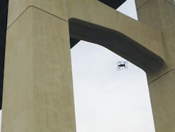
The senseFly albris UAV flies under a bridge deck in Minnesota.
Phase 1: Four bridges
While technologies and capabilities differ for the numerous UAVs available on the market, most have a number of features in common: they are powered by rechargeable batteries, controlled either autonomously or with a remote control device, contain four to eight rotors, have the ability to use GPS to track location, contain fail-safes such as return to home technology, and include cameras with both video and still image capabilities.
In phase one of the project to establish the effectiveness of drones for bridge inspection, the team used an Aeryon SkyRanger UAV to inspect four Minnesota bridges of varying sizes and types.
These four bridges were flown following the preparation of a detailed field-work plan. This addressed safety, Federal Aviation Administration (FAA) rules and inspection methods. Several imaging devices were also tested, including still image, video and infrared cameras. Various types of data were collected in the field, including still images, video, infrared images, site maps and 3-D models of bridge elements.
The SkyRanger proved to be a very robust and capable unit, and offered several advantages for the study: its all-weather capabilities allowed researchers to work in the rain, and it also has the ability to change payloads, meaning the team could use a standard camera, an optical zoom camera, and an infrared camera.
On the downside, however, the SkyRanger did not have the ability to look directly upwards, making it necessary to install a 360° video camera on top. Because of Wi-Fi signal interference, this did not perform correctly. In addition, the SkyRanger did not have the ability to fly under bridge decks because the loss of GPS signal would cause the drone to fly vertically and return to the launch point—obviously problematic with a bridge deck overhead.
Phase 2: Looking up
For phase two, at present the team is working with another UAV, the senseFly albris (previously called eXom). This is designed specifically for high-detail inspection work. Researchers chose this system to again inspect different types of bridges, including bridges featuring very confined spaces, such as culverts and box girders, and to conduct deck delamination assessments using the albris’ thermal camera.
The albris has the ability to look directly up and operate without GPS, so it can fly under bridge decks. It also offers infrared thermography and includes ultrasonic proximity sensors to help the operator avoid contact with the structure.
The results confirmed thus far have shown that UAVs are capable of effectively replicating the inspection detail learned through the use of snoopers and other traditional access equipment, without traffic-control requirements, and at significantly lower costs in terms of equipment and traffic control needs. Drones can provide both infrared and 3-D modeling detail of bridges, effectively identify concrete delamination, gather topographic mapping detail and efficiently map riverbank conditions, upstream and downstream, from the bridge site.
At a cost level, based on traditional methods of inspection, the second largest bridge in Minnesota would typically require three snooper inspection vehicles and a total of eight inspection days. This equates to a minimum cost of approximately $59,000, excluding equipment mobilization and travel expenses.
In contrast, the cost of a UAV contract to inspect the exact same approach spans of the project’s sample bridge would be around $20,000 with only five days onsite as per a consultant-obtained quote—a potential cost saving of 66%. This is a substantial saving and suggests that inspection via drone will have a significant impact on the outgoing costs of a transportation department.
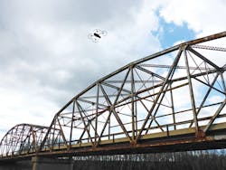
The albris inspects a bridge from above.
Looking ahead
Bridge inspection presents unique challenges, and identifying the right tool for the job is crucial if we are to ensure that UAVs are effectively cutting costs and time. The good news is that drone technology has come a long way in recent years, with companies such as senseFly having dedicated research and development to developing drones that are exactly specified for such work.
Current FAA regulations are slowing the adoption of UAVs for bridge safety inspections, as the time required to obtain approvals is significant and cost prohibitive. However, proposed FAA rules are set to remove many or all of these obstacles to widespread adoption in the hopefully near future.
MnDOT is working to initiate a policy for bridges that meet certain condition criteria—i.e. those in poor condition or with access requirements—that will require close-up inspection every three to six years. The access requirements could potentially be very costly to meet this policy, especially for local agencies, and inspection by UAV holds the potential to alleviate a lot of these costs.
The research team’s goal is to implement a statewide UAV contract to obtain close-up inspection data for all bridges meeting this policy’s criteria, on a set cycle, for both state-owned and locally owned bridges. The findings from phase two and potential subsequent phases of the research will be pivotal with regards to funding and state aid involvement. MnDOT’s full Phase 1 report is available at www.dot.state.mn.us/research/TS/2015/201540.pdf.


