Optimizing Infrastructure Management
By Sinan Abood, Contributing Author
Public transportation agencies are under growing pressure to curb costs while ensuring safety. Yet traditional methods for monitoring road assets—physically inspecting roads by truck or by video camera mounted on a van—are time-consuming, subjective, and inconsistent.
Such methods often delay projects and can cost $500-700 a kilometer per year.
Innovations in data collection technology — including unmanned aircraft systems (UAS)/drone systems, sensors, and geographic information systems (GIS) mapping — enable drones to collect and analyze aerial data on roads and bridges, helping highway personnel optimize infrastructure management.
State transportation departments that have integrated UAS/drone data collection and analytics systems have shown improvement in safety, efficiency, and cost reductions, according to an independent study from Purdue University.
Further, the Massachusetts Department of Transportation (MassDOT) has demonstrated in previous studies that UAS/drone technology improves safety. This aligns with the Biden Administration’s goal of reducing serious and fatal injuries on state roadways.
Using drones for highway inspections represents a comprehensive approach to enhancing roadway safety. It improves safety by reducing the time highway crews spend exposed to dangerous traffic conditions and can eliminate the need for hazardous lane closures. This also promises to minimize risks to the public.
Thanks to funding from Federal Highway Administration’s Accelerated Innovation Deployment (AID) demonstration grant program, MassDOT Aeronautics uses drones to collect and analyze data on the commonwealth’s highways and bridges. MassDOT also utilizes a UAS/drone data and analytics and cybersecurity program for surface transportation with the FHWA’s support.
The resulting “digital software systems” infrastructure empowers MassDOT Highway workers and managers to improve the effectiveness and efficiency of surface transportation maintenance, safety, and strategic planning.
Benefits of Aerial Data Collection
The integration of UAS/drone technology does not replace MassDOT Highway’s methods for operations and management.
Rather, it provides MassDOT Highway employees with additional resources for safer, more efficient, less costly inspections. It also improves working conditions, road safety, and strategic planning through a data-driven strategy for assessing and addressing surface transportation assets across Massachusetts.
The project’s three stages were designed to integrate with MassDOT Highway operations across the commonwealth, from rural to urban locations.
Phase 1 consisted of integrating UAS/drone technology into highway operations and management. For the project’s initial Alpha phase, MassDOT Aeronautics received $1 million in 2021 from FHWA’s AID grant program, which MassDOT matched with $250,000.
This initial phase tested and deployed UAS/drone technology integration for four proof of concept (pilot) projects in western, central, and eastern Massachusetts. Types of projects included construction monitoring and highway corridor asset detection/inspection.
Construction Analysis and Monitoring
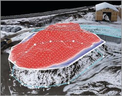
MassDOT Aeronautics’ Drone Operations team recorded this below image during the project’s first phase. The image and related analytics are designed to help facilitate the planned construction of a park and ride in Framingham, Mass. — by efficiently identifying assets and monitoring construction progress.
This will improve construction project management by quantifying the amount of cut and fill and asphalt used by the contractor.
MassDOT Aeronautics also developed a digital infrastructure for integrating UAS technology into all aspects of highway operation and management, a flexible framework that can be applied to workflows.
Creating a digital infrastructure entailed developing a robust framework by managing drone operations, securely storing and analyzing UAS/drone sensor data, and securely disseminating the end products to MassDOT Highway end-users through an application centrally located on GeoDOT.
The application portal enables MassDOT Highway personnel to access, share, upload/overlay CAD plans, as well as collaborate on the program’s geospatial data and applications. The project also provides a continuous feedback loop between the data team and Highway staff, ensuring improvement through regular meetings and embedded digital surveys.
Enhancing Workforce Development
The World Economic Forum predicts that 50% of jobs will require retraining in the next two years, with 40% of this education lasting six months.
Investment in redesigning work to include UAS-based GIS data is predicted to yield a competitive advantage for road maintenance employees, whose time will be used more effectively across various domains.
By providing MassDOT Highway employees the skills needed to participate fully in the workplace of the future, this project enhances employee retention in a constantly changing labor market.
To these ends, the program is developing online tutorials to train MassDOT Highway administrators, program managers, and staff to leverage the analytics tools and resources in the data infrastructure portal.
Each tutorial will include an assessment, the results of which will be used for continual improvement of the educational product. The program will also develop a plan to train MassDOT Highway end-users on Aeronautics Hub, a digital application for accessing UAS-developed products and applications.
Automation and Machine Learning
Phase 2 focuses on automation, artificial intelligence, and machine learning. MassDOT Aeronautics has applied for the FHWA’s AID program funding for the second planned “Bravo” phase.
This second phase expands the project in several ways: geographically by monitoring in rural and urban locations; technologically by automating data processing pipelines and introducing advanced AI, machine learning, and deep learning algorithms; situationally by expanding types of use cases to bridge inspection, road condition analysis, and potentially, to the creation of digital twins and vegetation management.
In Phase 3, the program turns to state-wide expansion. The digital infrastructure system will expand across Massachusetts, ensuring comprehensive coverage and enhanced operational efficiency statewide.
By providing unique data-based resources, insights, and training, MassDOT’s UAS/drone data analytics project underscores a commitment to pioneering technology-driven solutions to improve public safety and efficiency, providing a national model to make surface transportation safer, more responsive to public needs, and more adaptable to new technologies. RB
Sinan Abood, Ph.D. GISP, is a data and analytics team leader for the Massachusetts Department of Transportation, Aeronautics Division (MassDOT Aeronautics).
