Redefining urban rail in the U.S.
Since 1956, New York has had the option of two modes of public transportation within the city. One is very expensive to build and maintain and really is only practical for heavily traveled corridors, while the other option is slow with high per capita operations costs. These two modes of subway and bus have defined New York City’s urban transit for over 60 years with a subway system oriented at getting people into and out of Manhattan. Despite the fact that there are over 450 subway stations—and that Brooklyn alone once had the largest streetcar fleet in the nation with thousands of cars in operation—there are many parts of New York that rely on long, unreliable bus routes to connect to the subway.
This is beginning to change with the recognition of a need for an intermediary mode. For several decades various streetcar and light-rail lines have been proposed and discussed, and in some cases preliminary studies conducted. None of these have managed to find enough support to push forward until recently.
While Manhattan is still the destination for many people, the Brooklyn-Queens waterfront, just across from Manhattan, has seen formally industrial neighborhoods transform into new dynamic residential neighborhoods with extensive new commercial development. Increasingly, travel options running north and south along the growing Brooklyn and Queens East River waterfront are required to connect people to new job centers, and better connect some of the largest public housing communities in the nation to jobs and the rest of the city.
In 2015, a community proposal came forward with a proposed streetcar route, that they dubbed the Brooklyn-Queens Connector (BQX). After careful consideration and review, Mayor Bill de Blasio announced in 2016 that the city would build a modern streetcar line running along the Brooklyn-Queens waterfront that followed a similar route as that of the community-driven proposal. Over the next two years the city brought on the engineering firms of HDR and WSP to do a series of feasibility studies and conceptual engineering reports to not only consider the possibility, but study different alignment options and determine the best route based on ridership and the physical capacity of the streets to accommodate dedicated streetcar lanes.
The BQX is one of the largest infrastructure projects the city has ever undertaken at a cost of around $2.6 billion for an 11-mile route running from Red Hook in Brooklyn, a former industrial port neighborhood, to the multicultural community of Astoria in Queens. It also will be the first rail transit that the city has undertaken since some subway extensions in the 1950s, as the operations of the city-owned subway were turned over to the state in a series of actions starting in the 1950s. The BQX will be one of the largest new start urban rail projects when it is complete in 2029. It also will be one of the largest P3s (which is currently the assumed delivery method) undertaken in the U.S. to date.
Project funding
In conjunction with the engineering study, a parallel Value Capture analysis was conducted that looked at the potential to raise money from “Tax Increment Financing.” This funding method is based on the fact that well-planned and placed urban rail projects create increased land value, which can be “captured” by taking a portion of the increased property taxes collected based on the higher value and dedicating them to the construction of the line. In order to determine the potential value, detailed property and block-by-block studies had to be conducted.
Initially it was thought that Value Capture could pay for the entire line, but in the end a series of important priorities that allocated revenues from approved increased density meant this was not the case.
In particular, one important new city council stipulation required new property tax revenue from increased density derived through rezonings go to “Mandatory Inclusionary Housing,” a type of affordable housing which guarantees that new developments have a mixture of income levels. This meant that a lot of the revenue expected from new development that would be supported and incentivized by the BQX will now go to increased affordable housing in the corridor, making sure that as the neighborhoods change and evolve, a place is protected for people of all income bands. Earlier analysis had assumed this money would fund the BQX capital costs.
Similar commercial and industrial programs further reduced the total take from Value Capture, but are important components of creating a diverse, livable city, one of the objectives of the BQX.
In the end over half of the construction cost will come from Value Capture, with most of the value being derived from the property taxes coming from the increased value of property near the line, and new development. The calculation is likely on the more conservative side as it assumed there would be no new rezonings (either of public or private origin) over the next 40 years, which seems unrealistic in a New York City context.
The concept: urban light rail
The BQX was announced as a streetcar line, but as study proceeded, it was determined that in order for it to be a useful piece of transportation infrastructure, it would need to be able to achieve a high degree of reliability and speed.
In a dense urban context like New York, this would require most of the line to be in physically separated rights-of-way or involve extensive traffic engineering as well as avoiding the curb lane, where deliveries are made and double-parking often occurs.
Due to the fact that much of the route of the BQX route is situated in streets of less than 40 ft wide and the larger wider streets are heavily traveled, the presence of the BQX will by definition require the removal of around 2,000 parking spots and the reduction of vehicle capacity.
The reduced space for private vehicles are consistent with the Vision Zero program of reducing pedestrian accidents as the streetcar/light-rail ROW will “calm” the streets by reducing the area available for cars. This will lead to slower traffic speeds, while at the same time increasing the carrying capacity of the streets as light-rail vehicles replace single-occupancy vehicles.
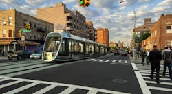
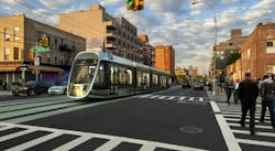
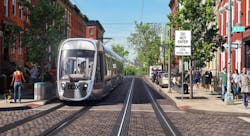
The BQX as planned to date has around 60% of the line in the center of the street with the rail bed to be either elevated by 6 in. between intersections (this avoids the need for the space taken by 6-in.-wide curbs on each side) or where more space is available, raised curbs may be employed.
In some sections, where there is little curbside activity or crossings, there will be curbside operations and in some small sections, traffic engineering will be used to reduce traffic along what will become a “Transit Mall”. In these areas, private vehicles will be allowed, but a series of one-way streets will force traffic off after a couple of blocks, reducing dramatically the traffic on these streets that could impede the BQX.
BQX stops will be located every half-mile; there will be signal priority and low-floor light-rail vehicles will facilitate boarding and comply with ADA legislation. The combination of easy and fast boarding, physical separation of the route, traffic engineering, transit signal priority and stop spacing along the route will allow the BQX to achieve an average speed of 10 mph, or about two-thirds the speed of most of the subways and 50% faster than buses in the corridor.
While 10 mph sounds low, it is similar to most urban light-rail systems around the world and is reflective of the need to make many turns as the BQX navigates neighborhoods with few long, straight sections of road. Additionally, since the BQX will be mostly used to connect to and from other higher-order transit services like subway and commuter rail, the average distance traveled will be in the 2-mile range, making reliability (mostly created by separating the line from traffic and giving it signal priority) more important.
Conceptual engineering and utilities—the single largest budget component
The conceptual engineering involved preliminary work on a maintenance and storage facility, the alignment, power supply system, bridge construction or retrofit options (the line crosses one navigable waterway), and laying out the track geometry to determine that BQX could “fit” into the compact and narrow street grid. This last point was especially important as the 19th-century street grid had few wide straight street sections, and the issue of fitting in stops and navigating tight turns (less than 35 ft) was considered in detail.
It is expected that the BQX will require a non-standard vehicle—more akin to new modern light-rail vehicles recently procured in Toronto and under consideration in Philadelphia—to be able to navigate tight turns. Similarly off-wire technology may be an advantage (and will be further considered in the next phase) as space is limited for the installation of an overhead catenary system, and there may be objections to new wires in old historic neighborhoods.
The other area of extensive work was around the determination of the location of underground utilities. The entire corridor has had substantial residential and industrial development for well over a century and is near the water. This means there are large, 15-ft-plus wide gravity feed sewers and extensive large water mains that need to be accounted for.
In addition, there are extensive gas and underground electrical conduits. Most electrical transmission in this part of New York is via underground “Oil-o-Statics” lines which are high voltage electrical transmission lines encased in oil for cooling purposes. They are highly expensive and difficult to move, as well as requiring specialized crews and space within the roadway for the relocation.
Due to the large number of utilities and fairly narrow streets that presented a challenge for relocation, an extensive utility pit program was initiated along the entire corridor, where close to 80 pits were dug. This went along with over 25 miles of LiDAR—a survey tool that uses light from a radar, along the lines of radar to produce detailed plans of the physical form of the street and all of the associated elements—that helped determine the presence of utilities and other obstacles to curb relocations associated with the moving of utilities or installation of the rail bed. This included street furniture elements like poles and fire hydrants as well as elements like trees and the presence of underground private vaults for utilities and other non-legal but grandfathered extensions of basements into the public right-of-way.
While much work must still be done on how the utilities question is to be handled, about a third of the budget was allocated to utility relocation.
In the end, it was assumed that most of the sewers would be left in place and, after inspection, would be repaired and strengthened to avoid the need for future work.
The final route does not have any major Oil-o-Statics within the path of the alignment, which avoids the time and cost of major relocation of these difficult-to-move pieces of infrastructure. Despite the policy to strengthen and leave in place most of the large infrastructure, a large amount of water mains, smaller sewers, communications conduits, and smaller electrical conduits will have to be moved, which will be expensive and require several years of work.
Conclusions and next steps
By combining the best of traditional streetcar and light-rail systems, the BQX highbred, a type of “Urban LRT,” allows New York City to fill in a gap in its tool kit for rapid transit. It also enables the city to create a template for other corridors in New York which require more than regular subway, but do not have sufficient passenger levels to justify the investment in heavy-rail meter operations.
The city has begun the process to select consultants to complete the environmental review. When it is complete, it will then move into preliminary design (to take the design to around 25%) and a further delivery vehicle (“Value for Money”) qualitative and quantitative analysis to determine the best way to deliver the project.
With such a large project, in a complex urban environment, a lot of work remains. Construction is expected to begin in the mid-2020s and be complete by the end of the decade. The line will connect with many of the busiest subway lines, tie communities together and is expected to carry over 55,000 passengers on opening day.


