By: Brian W. Budzynski, Bill Wilson and Tim Bruns
The American Southwest is synonymous with a rough-and-tumble variation of national purity and industry. From homesteading and large-scale ranch developments to the popularized advent of the serial western, the Southwest has been a captivating portion of the national landscape since the days of its first exploration and settlement. In this region, state DOTs face unique challenges in the face of modest funding availability. For this report, we highlight three Southwestern states to find out the present state of their road and bridge infrastructure system—and to peer into what the future may hold as 2016’s FAST Act begins to yield its fiscal effect.
UTAH:
“We’ve solved structurally deficient”
by Brian W. Budzynski, Managing Editor
That is quite a bold statement, given the current state of the national road and bridge infrastructure.
But Utah Department of Transportation (UDOT) Executive Director Carlos Braceras spoke to Roads & Bridges with absolute confidence regarding his state-owned
bridge inventory.
“Locals have more of a challenge, of course,” Braceras said. “They have less funding. [But] we have about 1,900 state-maintained bridges, of which only 18 are presently structurally deficient. That’s less than 1% of inventory. And all 18 are programmed for replacement or rehabilitation by 2018.”
Overall, Utah has, according to the FHWA, 481 bridges classified as structurally deficient or functionally obsolete, translating to 16% of total bridges in the state. This is a modest percentage compared with the staggering figures in states like Rhode Island (56%), Pennsylvania (40%) and Massachusetts (52%). Accounting for such relative success in general infrastructure maintenance, Braceras was quick to address the struggle inherent in road and bridge building and maintenance.
“This is about not passing on a liability to future generations,” he said. “We’re a relatively small DOT, but we have goals similar to other DOTs, safety being the primary. Moving toward zero fatalities, improving mobility, keeping with system preservation—that’s where we’re at.”
Ratcheted in
According to TRIP, Utah’s roads withstand 27 billion vehicle miles of travel annually. More than 60% of land across the state is federally owned, and much of the state’s topography is either mountainous or rural, with isolated urban pockets tucked in between. Vehicle travel has increased 84% since 1990, and it is expected that statewide population will double by 2050, after a 66% increase from 1990-2014.
In light of these statistics, it has been incumbent on the legislature to provide sustainable means of amending the road and bridge network to such growth. This past January, a gas tax increase went into effect, raising the tax per gallon from 24.5 cents to 29.5 cents. The bill authorizing the tax boost came wrapped in an index provision, by which the tax can increase with the cost of gas to a ceiling of 40 cents per gallon, but cannot go below the level set by the current 5-cent hike .
“It’s locked in, so that like a ratchet it can only go up,” said Braceras. “It can’t go down. The legislature didn’t pick projects. They passed the gas tax to get a lower cost of ownership. Good roads and bridges cost less, and the legislature understands that.”
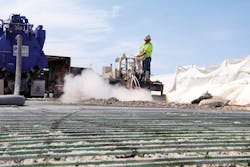
Crews are employing a novel system of high-pressure water jets to enable demolition on bridge decks along the I-215 project site. As shown, the top-most concrete is removed while sustaining the underlying steel for resurfacing.
The big-ticket stuff
“The Salt Lake valley is pretty much filling in from mountain to mountain,” Tim Rose, project director for UDOT’s I-15 “The Point” project told Roads & Bridges. “The only thing stopping it are the lakes and mountains.”
“The Point” is the only major corridor into and out of the valley, and thus has been, over the last several years, the state’s largest multi-let project.
“The 7-mile section we’re working on now gets 160,000 vehicles per day,” Rose said. “So we’re doing new pavements, new bridges, a new interchange at 14600 South—the whole shebang. This project was chosen because it’s what we could afford to build based on available funding and very definite need. We absolutely expect to have this project wrapped up at the end of this construction season. All the paving is done. We’re working on lane striping and finishing up the interchange area at 14600 South. It’s crazy congested—at least it was. Now that we’re nearly done, it’s pretty free-flowing.”
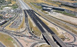
A little further north, in Salt Lake County, I-215, which straddles the suburbs south of Salt Lake City, is in the midst of a well-earned overhaul.
“I-215 is a belt route for I-15 and serves 148,000 vehicles per day,” Oanh Le-Spradlin, UDOT project manager, told Roads & Bridges. “It’s been 40 years since initial construction, and this is the first major overhaul. The road was in dire need.”
The 9-mile project will boost the corridor to four lanes in each direction, and rehabilitate or replace nine bridges. The project is seen by UDOT as exemplifying its philosophy of long life and smart application of funds.
“We want to use our tax dollars as effectively as we can,” said Le-Spradlin, “and we target a lifespan of at least 40 years when rehabbing or reconstructing a bridge. So we salvage what we can and replace what we need to. We’re going full depth on the road section for the most part. There are three miles that will just get the top 8 in. of asphalt, but the rest is being widened for an auxiliary lane near the interchanges and done full-depth with concrete. Asphalt is largely being used near ramps which will see more pressure, in places we know we’ll [revisit] more often.”
When the project is completed next fall, it is expected that congestion will see a significant reduction. “It’s been proceeding smoothly,” Le-Spradlin said. “We are going to be working throughout the year. All lanes and ramps will remain open. Given the scope of this project, getting it done in 18 months is incredible.”
The future
For UDOT, the future is not just about construction.
“The new and flashy thing every DOT is looking at is connected and autonomous vehicles,” Braceras said. “We’re all dreaming of this getting us to zero fatalities. So we’re thinking through what we need to do to be prepared as a state, both in terms of the facilities that are out there and the knowledge we possess as a DOT, so we can make mobility better and safer. Right now, we use a single traffic signal system statewide. If it’s a city, state, county signal, it’s on the same system, same software and hardware. We have 85% of signals in the state connected to one fiber-optic backbone at our ops center. We can coordinate traffic systems across jurisdictional boundaries, which will provide consistency for connected-vehicle environments. As more and more automobiles come out with dedicated shortwave radio in them, our system will be ready to accommodate them.”
ARIZONA:
Fighting the flood of traffic
by Bill Wilson, Editorial Director
The Arizona Department of Transportation (ADOT) does not like to see anything hit the area in a flash. In early August, the state was dealing with flooding—a rare occurrence in the desert. Over the last few years, ADOT has been trying to get a handle on traffic before it becomes an instant crisis.
A five-year plan along with several major projects around the metro areas should help soothe congestion in the near future. The Loop 202 South Mountain Freeway project has been talked about for years and will finally be given life in 2016. The 22-mile freeway—the last piece to complete the Loop 202 and Loop 101 freeway system—will follow a route south of South Mountain from I-10 east of central Phoenix at Pecos Road, and will reconnect with I-10 west of central Phoenix at 51st Avenue.
“There are, at this point, no freeways that take traffic from Ahwatukee to the west,” Tom Herrmann, spokeperson for ADOT, told Roads & Bridges. “It’s an opportunity for people in the Ahwatukee area and the southern part of the Phoenix metro area to go to the west side of Phoenix or the west side of Arizona a little faster.”
The link also will provide an alternate route for commercial and private I-10 drivers traveling between Tucson and Los Angeles to bypass the central Phoenix corridor.
There is a massive $300 million effort in Pima County to improve I-10 and I-19 around Tucson. The I-10/Ina Road traffic interchange project has just begun, and crews will place Ina Road on a bridge over I-10 and the Union Pacific Railroad to improve traffic flow and safety in the area. Both I-10 and Ina Road also will be widened. Ina Road will have two lanes in each direction and I-10 will have a total of six lanes.
Another project which kicked off early in 2016 was the I-19/S.R. 86 traffic interchange. The work will improve traffic flow on both Ajo Road and I-19, and this will be the first interchange south of the junction of I-10 and I-19 in Tucson.
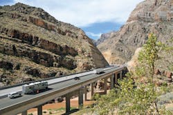
The Arizona DOT is implementing a five-year plan to improve infrastructure and ease traffic congestion across the state. Photo courtesy of the Arizona DOT.
Road and bridge activity in Arizona is perhaps at its highest in Tucson as one other major project is unfolding and two more are set for takeoff. The I-10/Ruthrauff Road traffic interchange project will lower I-10 to ground level and raise Ruthrauff Road over I-10. Ruthrauff Road will have two lanes of traffic in each direction, while I-10 will be widened to four lanes in each direction.
Two more interchanges along I-10 involving Houghton Road and Country Club Road will be improved in the coming years.
Outside of the Tucson work, projects on S.R. 189 and S.R. 347 also carry a heavy impact. The $70 million S.R. 189, Nogales to I-19 project is designed to ensure international commerce can safely and efficiently move between the U.S./Mexican border and I-19, and from there to I-10, the primary route for commercial traffic between southern California and Texas.
ADOT also will be building an overpass for S.R. 347 over Union Pacific Railroad tracks at the Maricopa-Casa Grande Highway in Maricopa. S.R. 347 currently crosses the Union Pacific tracks at ground level, and the new bridge will alleviate congestion. Total cost for the work will be $55 million.
One major project near completion is Loop 101, which is a circle freeway around the Phoenix area and provides four lanes and an HOV lane in each direction.
“Arizona is still growing at a great rate and the demand for roads is still very high, but we think we have done a good job keeping [them] in the position where, No. 1, they are in good condition and No. 2 they meet the needs of a growing population,” said Herrmann.
ADOT is in the process of planning for FAST Act dollars. The state is on track to receive a $54 million federal grant to help fund two key widening projects (from two lanes in each direction to three lanes) between Casa Grande and Tucson and add traffic-management technology that will include a dust-storm detection and warning system along I-10.
“We have many cameras across the state that we use for traffic management, and we are looking to put some in that area so we can get a better feel,” said Herrmann.
Messages will describe when a storm is expected to hit and how long it will last, as well as the current visibility in the area.
As for the flooding that occurred in August, ADOT was reporting no pavement or bridge damage at press time. An underpass on I-10 in Tucson was flooded and closed for about five or six hours, and a spot on I-17 and Indian School Road in Phoenix was shut down for four or five hours.
NEVADA:
Hi-oh Silver, away!
by Tim Bruns, Associate Editor
With over a dozen major road construction projects in the works, the Nevada Department of Transportation (NDOT) is focusing on its objective of keeping the citizens of the Silver State on the move.
“Ultimately, our main mission is to provide a transportation system that keeps Nevada safe and connected,” NDOT Public Information Officer Meg Ragonese told Roads & Bridges.
The department receives approximately $250 million in federal funding under MAP-21 and SAFETEA-LU appropriations. In addition, NDOT receives $200 million in state funding specifically for road and bridge construction. These funds enable the transportation agency to secure critical transportation improvements for some of the fastest-growing population bases in the nation, according to Ragonese.
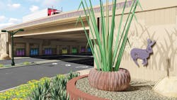
A digital mock-up of the vision for the Neon Gateway HOV interchange.
Going ‘Neon’
One such major improvements project is the continuing work on I-15 in Las Vegas, a major freight and commuter corridor that transports just under $200 billion in commercial and tourism revenue on an annual basis through Nevada and its surrounding states.
Present construction on I-15, currently the busiest stretch of highway in Nevada, includes a $1 billion widening of the interstate that involves converting two existing express lanes into a general purpose and a high-occupancy vehicle (HOV) lane. Dubbed ‘Project Neon,’ the widening effort would create 22 consecutive miles of carpool lanes in the Las Vegas Valley.
“What we’re doing is building a quarter-mile long flyover structure from the center or the median of U.S. 95 to I-15 and, when the project’s done, converting those express lanes to an HOV lane and a general purpose lane,” Dale Keller, NDOT Project Manger for Project Neon, told Roads & Bridges. “For the first time, we will have real functionality and usefulness out of an HOV system.”
The aforementioned flyover bridge is the centerpiece of Project Neon. At 81 ft tall and 2,606 ft long, the HOV flyover will also accommodate northbound traffic from I-15 to U.S. 95. HOV lanes will allow carpoolers and rapid transit in downtown Las Vegas to access the Neon Gateway HOV interchange. In addition, according to Keller, NDOT is recreating the Charleston Interchange into a diamond interchange.
Along with carpool lanes, NDOT is implementing other engineering solutions to boost traffic flow and reduce accidents in the Las Vegas area by introducing ramp braiding. “We experience three or more accidents a day in this corridor, and a lot of that’s due to lane competition,” Keller said. “So by introducing ramp braiding, we believe we’ll see a large reduction in those accidents.”
NDOT has partnered with the FHWA as well as with the city of Las Vegas to put up over $75 million for the project, which is just beginning its transition from the design-build phase into phase 1 of construction, which is expected to be complete by March 2018. The entirety of Project Neon is on target to be finished by July 2019.
A capital endeavor
Another major improvements project in Nevada can be found further north in the state, on the Carson City Freeway project. The $42 million project began last summer, and aims to open the last four miles of the Carson City Freeway to traffic between Fairview Drive and the Spooner/U.S. 50 junction in the southern part of the city.
“Essentially, you could drive from Reno all the way through Carson City, and then it will tie into U.S. 50 going up to Lake Tahoe, basically without really ever stopping,” NDOT Assistant District Engineer for Construction Rick Bosch told Roads & Bridges.
One of the most challenging components of the project so far included a substantial excavation effort of moving approximately 650,000 cu yd of earth from the future freeway, according to Will Hellickson, project manager for the freeway’s contractor, Road and Highway Builders (RHB). “In order to do that, we used an overlay conveyor system, about a half-mile long, that actually runs under the existing South Carson Street,” Hellickson told Roads & Bridges. “We did that in order to alleviate congestion and the logistics issues of having trucks cross busy streets.”
Hellickson said at this stage of construction, RHB is about 30% through with installing the 3 miles of sound walls for the freeway and is preparing for asphalt paving next month. Between now and the fall, he expects the majority of work on asphalt paving and sound walls to be finished.
The final segment of the freeway in Nevada’s capital city is expected to be open to traffic in 2017. NDOT officials estimate that 43,000 vehicles will use the section of freeway on a daily basis by 2035.
Sound wall installation is a major component of the Carson City Freeway project in Nevada.
All about preservation
Being in the nation’s driest state, NDOT officials prioritize water preservation efforts as important components of their construction projects. Steps taken to preserve water in the state, according to Ragonese, include enhancing stormwater management and drainage as well as protecting the quality of stormwater exiting department facilities and work sites. Lake Tahoe in the northern region of the state is one such environmental resource NDOT prioritizes to protect in the midst of construction.
Among the roughly 1,900 pieces of heavy equipment used by NDOT, approximately half of their maintenance fleet is approaching the age for replacement. As a result, a rebuild program was initiated to extend the life of certain equipment and rebuild it to an improved condition for significantly less than the cost of purchasing new equipment.
In addition to aging equipment, aging bridges across the state are also a major concern for NDOT officials. After spending nearly $33 million in 2013 and 2014 on bridge preservation, officials expect the need for bridge rehabilitation and replacement funds to increase over the next decade as a result of the state’s maturing bridges.
--------------
The Region Report series will continue in December (Upper Great Plains). Installments in 2017 will include: The Great Lakes Region, The Northeast and The West Coast.
