How to develop a proactive resiliency framework in your planning programs or organizational approach
When is the best time to solve a problem?
Answer: Before it happens. Resiliency is all about being proactive rather than reactive. Taking action today will save time, money, and lives down the road.
This is true for floods, wildfires, and, yes, pandemics. The COVID-19 outbreak has shown the importance of reliable infrastructure in keeping people safely connected. Formerly rare extreme weather events are now commonplace, and infrastructure planning needs to account for the potential impacts and disruption with response and recovery plans that minimize disruptions while improving safety.
The good news is that today we have answers. A resiliency planning framework exists to help in preparing for the worst. Transportation resiliency planning has gained popularity in the wake of severe weather events like Hurricane Katrina and Superstorm Sandy. Communities around the country are learning that investing in resiliency planning can lead to exponential savings in the long term and can help mitigate the severity of a disaster’s impact. Developing and implementing an infrastructure resiliency plan gives communities the tools they need to protect critical infrastructure even if that disaster does strike—and potentially even prevent an extreme event from turning into a disaster.
At its basic level, the key to resiliency planning is to gather all necessary information about transportation infrastructure assets, and identify which are vulnerable and which are critical. From there, policy makers, department leaders, and professional consultants can develop mitigation strategies to minimize the impact of a disaster—or potentially avoid that impact altogether. This can translate into savings over time. Reacting to a disaster, rather than planning for it, is often more expensive with emergency repairs demanding a premium.
A Framework for Planning & Implementation
Building resilient infrastructure does not mean fully preparing for any and all potential disasters. It is about assessing the hierarchy of needs in a holistic, methodical way. In one area that might mean building roads higher, relative to average water elevations, in order to resist floods; in another that could mean making sure critical infrastructure is safe from potential wildfires. It is all about having the information needed to prioritize those actions and then a process for determining what to do when and at what magnitude.
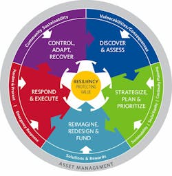
There are five key phases in a resiliency plan:
I. Discover and assess. The first step is to identify all system assets to be assessed and perform a GIS analysis of existing databases. Stakeholders are engaged and social, economic, and environmental goals are also incorporated during this phase.
II. Strategize, plan, and prioritize. This is the part of the resilience framework where identified risk is used to vet solutions, relying heavily on stakeholder engagement.
III. Reimagine, redesign, and fund. Here solutions, innovation, imagination, and policy are turned into reality. All funding options should be considered, from traditional sources such as tax revenue to creative solutions like cost-sharing.
IV. Respond and execute. This phase enables the current emergency response processes to be incorporated into resiliency planning. This can also be a two-way street, where emergency responders learn from and incorporate resilient actions into their plans.
V. Control, adapt, and recover. After an event, there are still opportunities to be proactive. Asset management, long-term logistical planning, even pre-positioned documentation/contracting that is all designed to speed and aid the recovery process.
This framework is successful no matter the hazard and no matter the project’s stage. And when risks change and priorities shift, the process can be repeated.
Customized Approach to Reflect Community Assets & Needs
While the overall process is relatively straightforward, the details associated with each step vary depending on the purpose of the resiliency analysis and the perspective of the decision maker. For example, when constructing or repairing local roads, the analysis could focus solely on long-term maintenance costs and whether there is sufficient property tax revenue to improve infrastructure.
Alternatively, decision makers might want to take into account broader social factors. They might want to consider whether the investment reduces the potential for significant diversions and reflects equity considerations. For example, a roadway that is washed out could mean long detours that add travel time for residents to get to work or school. Prioritizing a heavily traveled roadway may be more important than choosing the least expensive road to maintain. Focusing on the goals of the analysis allows officials to be certain they are considering their identified priorities and using scarce fiscal resources most effectively.
Six months ago, the largest potential hazard to the nation’s infrastructure was most likely climate related. But the COVID-19 pandemic has served as a compelling reminder that disasters can take many forms. Though the virus does not physically impact infrastructure the way a storm or a flood might, the pandemic is having a dramatic impact on the way transportation is funded and operates. Although it is too late to prevent the pandemic, communities can adopt the final stage of this planning process and “control, adapt, and recover” from this crisis, leaving them better prepared for the next similar event.
Resiliency Planning Pays Long-Term Dividends
Three primary factors drive the increased interest in resiliency work: desire to reduce potential service failures, cost savings, and decreased risks.
The cost savings are significant: A 2018 study from the National Institute of Building Sciences found that communities that invest in mitigation see an average sixfold return. That is a lot of money saved by communities that take a proactive stance on hazards or threats. If leaders take the time planning to be resilient, they will enable their communities to have a leg up on hazards when they occur. And when that extreme weather event occurs, communities want to hear their leaders say “we planned for this.”
Fairfax County, Virginia, learned this lesson in the mid-2000s, when they invested in an automated flood warning system and developed a flood response plan that would tell the county when a flood would occur and how big it was going to be. Just a few years later, a tropical storm flooded the region. The system worked as it was supposed to and allowed flood managers to move assets, deploy personnel, and warn the public earlier than they would have otherwise been able to—and the program managers won awards for their handling of that disaster.
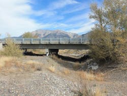
Other communities around the country are also investing in resiliency planning. The potential hazards change based on geography, but the approach to mitigation remains the same. One such community lies in Butte, Custer, and Lemhi Counties in Idaho. HDR helped the Idaho Transportation Department (ITD) evaluate the risk of hydrologic and structural failure of 33 bridges along a 160-mile corridor. ITD databases provided information to build a data dashboard reporting tool, allowing for a quick overview of bridge metrics, as-built drawings, and site photos. Ultimately ITD used the results to effectively prioritize which bridges to repair or upgrade as part of its capital improvement plan. This translates to a cost savings: When repair and replace is performed for several items of infrastructure instead of multiple one-offs, it typically produces a 25-40% cost savings.
Florida Keys Takes Holistic Approach
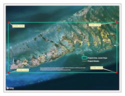
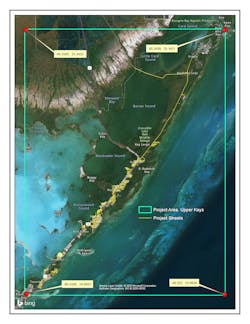
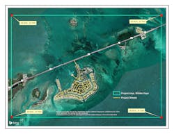
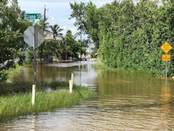
The Florida Keys are ground zero for climate change driven issues. As sea levels continue to rise, when the tide is exceptionally high, water rises through the porous limestone ground and breaches existing ground elevations, overtopping the roads or sifting through drainage pipes and flooding the areas. The more this happens, the more accessibility is compromised, roadway deterioration is accelerated, and the salt in the water corrodes vehicles and exposed infrastructure. Eventually, some roads will need to be raised and in certain instances potentially abandoned or maintained in “as is” condition. Because the Keys are so spread out, some communities are served by a single road, so the loss of any one can have a dramatic impact on a whole community.
Monroe County, population of approximately 75,000 in the Keys, has taken a proactive approach to resiliency planning. County leaders asked HDR to perform a detailed analysis of 1,200 county-maintained roadway segments—314 miles in all—and rank them in terms of vulnerability and cost-effectiveness of repair. This includes an assessment of other factors, such as regulatory issues associated with doing the necessary repairs.
Eventually, the county’s leaders will have to make tough, expensive decisions about which roads to raise first. Rather than waiting until it is a crisis, Monroe County officials invested in resiliency planning to equip them with enough data to identify which roads need to be elevated now and which can get by with less expensive repairs to extend their service life. As part of this evaluation, HDR analyzed water level projections, existing ground elevations, and available GIS county information to produce data sets including vulnerable areas, infrastructure impacts, environmental impacts, right-of-way needs, and timing issues. This proactive approach allows those leaders to spend their money where it will be most effective and save money in areas where smaller investments can yield the same result.
At the end of the 2½ year study, the county will be able to make strategic choices with this forward-thinking, holistic approach that will save money by targeting the highest-need areas first and lead to more efficient spending. Communities around the country would experience the same benefits from similar planning efforts.
Proactive, resilient actions can reduce service failures, produce a significant benefit-to-cost ratio for projects, and reduce risk and liability over time. The best place to start is to assess your assets, find the most vulnerable or critical ones, and to develop your resiliency goals. Remember, the best time to start is right now.
