Technology, innovation, and coordination help Florida manage emergency evacuations
By: Craig Toth, P.E.
When a hurricane struck Galveston, Texas, in 1900, as many as 12,000 people were drowned by the flooding and swept into the sea.
It was the deadliest natural disaster in U.S. history. The primary problem, in that case, was faulty weather forecasting, which precluded any attempt at evacuation. But even with accurate and timely information, the evacuation would have been challenging.
Thanks to improved warning and response systems, we no longer face losses of that magnitude. But coordinated evacuation plans have a long way to go. Millions can certainly be stuck in the sea of cars hitting the highways as they attempt to flee. And the potential misinformation that accompanies constantly meandering hurricane paths can magnify the physical, emotional, and economic effects of residents’ displacement.
Florida evacuations during hurricanes Irma in 2017 and Michael in 2018 benefited from several new mitigation efforts. Projects initiated by the Florida DOT (FDOT), in partnership with infrastructure firm HNTB Corp., resulted in more orderly evacuation traffic, fewer traffic incidents, and better access to available fuel.
Consistent with Florida’s determination to lead the country in transportation systems management and operations (TSM&O), multiple recent technology solutions are ready for the current hurricane season.
Emergency shoulder use
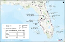
Emergency shoulder use (ESU) allows vehicles to travel on highway shoulders in the outgoing direction for evacuation. It is an alternative to the traditional idea of contraflow or one-way operation, which involves using incoming lanes for outgoing traffic. “Emergency shoulder use maintains two-way traffic to allow fuel, supplies, and necessary recovery resources into and throughout the state during evacuation,” said Trey Tillander, FDOT’s Director of Traffic Engineering and Operations.
By contrast, the resources and staging required for contraflow implementation are significantly greater. Signage, traffic control, and ramp access are barriers, and a large contingent of public safety staff is required to manage it. Contraflow also does not allow the flexibility to quickly adjust traffic if the hurricane changes its course.
HNTB had been conducting ESU microsimulations for the state in 2017 when Hurricane Irma approached. When the time came, nearly 6.8 million people were ordered to evacuate, and many of them used the shoulders. Some even found themselves evacuating twice, as the storm’s path changed course.
Part of the project included installing traffic monitoring systems on the shoulders to record and transmit volume and speed in near-real time. The information associated with these devices helped the state to respond as events unfurled with route alterations or ESU opening and closing. This data can be used to assist with future ESU operational decision-making.
Prior to implementation, the team inspected all eight routes developed for ESU to identify conflict points. Thanks to the state’s strict design manual and current infrastructure integrity, very few issues were identified. Where narrowed shoulders were identified, FDOT worked ahead to clear them or provided necessary notification to drivers via signage and portable and permanent dynamic message signs.
One of the challenges the traffic team faced was to ensure first-responder access and staging were clearly identified, especially around interchanges and rest areas. Working with the Florida Highway Patrol and other state agencies, they created a plan to pre-stage emergency assistance vehicles and leveraged the state’s intelligent transportation system (ITS) cameras and Regional Transportation Management Center (RTMC) staff to identify any vehicle breakdowns so they could be cleared quickly. Median openings were identified for access from the southbound lanes. And their preparation paid off. According to FDOT Emergency Coordination Officer Irene S. Cabral, the post-Irma analysis revealed no fatalities and very few traffic accidents.
HNTB’s RTMC staff also worked with FDOT to monitor evacuation efforts and provided updates on how well the ESU was working in real time. They continuously monitored average volume and lane speeds that allowed FDOT to adjust limits and coordinate with various agencies, such as law enforcement, to usher traffic in and out of the shoulder, monitor traffic exiting to find shelter or fuel, and ultimately allow the flexibility to extend shoulder use when needed and end it in a timely way.
Arterial traffic signal modifications
While it has not been implemented yet, Florida is also planning for traffic signal operations adjustments to accommodate sudden traffic change, using cameras and telecommunications hardware and software to remotely manage signals and keep traffic flowing during an evacuation. This is especially important during situations where traffic needs to cross the state to facilitate connections to alternative outbound routes.
Traveler information
Prior to and during hurricanes Irma and Michael, HNTB and FDOT coordinated dynamic message signs to provide unique traveler information. Again, thanks to remote ITS monitoring, they were able to notify drivers about shelter information, rest areas, and ESU openings and closings, and are continuing to add information to aid the state and drivers in making data-driven decisions.
The state also found its Florida 511 Advanced Traveler Information System platform extremely effective in keeping the public informed with real-time traffic information and route alternatives. The system includes a website, a mobile app, Twitter, Facebook, and Instagram feeds.
Additional solutions
Toll suspension in situations such as this is typically ordered by the governor, yet toll and service plazas played a vital role during recent evacuations. Extra staff was called in from every available resource to assist travelers with directions, gas distribution, and route-related questions.
After Hurricane Michael, 100 miles of I-10 were closed due to downed trees. Coordinating and prioritizing resources to clear the highway was challenging. The project team now is working on remote monitoring to help stage and prioritize debris removal, utility company work, and fuel logistics. Among other technology solutions:
- Based on lessons learned, the team is working on remote monitoring of backup generator fuel levels to keep ITS facilities running.
- They are considering how to use connected vehicle technology as part of the I-75 Florida Regional Advanced Mobility Elements (FRAME) project, designed to better manage, operate, and maintain the multimodal transportation system and create an integrated corridor management solution on I-75 and state highway systems in Gainesville and Ocala.
- FDOT is working on a GIS application that will include the availability of electric vehicle charging stations, fuel locations, traffic speed and volume, rest areas, and other ESU priority features.
- Finally, the partners are engaged in several projects to increase the resiliency of the ITS network, developing backup communication plans, working with other state and district DOTs to assist in maintaining cameras during outages, and leveraging the state’s Road Ranger Service Patrol to expand available assistance both during evacuations and in recovery.
These are all crucial aspects of the overall resiliency plan, but not every solution relies on remote monitoring and communication networks. Some are a bit more low-fi than that; nonetheless, they can have a profound effect on safety and operations. One such effective communication device is the flip-up sign, which can be installed and ready for deployment when an ESU plan, detour, or other change is enacted. The team also has worked with local agencies to develop mini-detour plans and signage support for drivers exiting local roads to fuel up. Similarly, establishing a complete GIS-based inventory of traffic signals, signs, light poles, and other features will aid in post-storm assessment and speedy recovery of critical infrastructure.
Florida’s 2019 “Bold Vision for a Brighter Future” budget supports the state’s efforts to position itself at the forefront of transportation technology. Hurricane preparation efforts provide some urgency for innovative work that will likely find application throughout the state.
About The Author: Toth is group engineering director for HNTB Corp., Florida.


